|
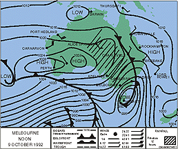 Look at a weather map taken from your local newspaper. You will find a map of your country on which a number of lines are super-imposed. The lines are called isobars . The air pressure at every point on a given isobar is the same.
A high pressure zone is associated with fine weather.
A low pressure zone signifies stormy weather.|
A hurricane or cyclone is signified by a low pressure zone of a particular type. In this case, the L zone appears to be relatively small, and the isobars are wrapped tightly around it. This shows that there are great differences in the air pressure, resulting in very strong winds.